Wednesday, October 19, 2011

Lesson Objectives & Assessment Guidelines

Major Objectives:
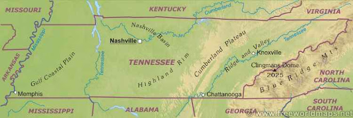
·    S.P.I. - 7.3.3 - Identify the major river systems of Tennessee
·    S.P.I. 7.3.7 - Identify, locate and compare the five largest cities in Tennessee on a bar graph
·    S.P.I. 7.3.12 - Identify the six physical regions of the state of Tennessee.

Guiding Question:
How much do you really know about your home state?

Mastery of Lesson:
Student must correctly label at least five of  the six physical regions of Tennessee on the map
Student must pass a Tennessee quiz at 85% mastery.

Mid-Lesson Assessment:
Students will draw a map of Tennessee and correctly label the six physical regions, major landforms and river systems, as well as the five major cities.

Final Unit Assessment:
·     Authentic Assessment:
o  Student Product of Tennessee - combination brochure/foldable/tryptich of the state reflecting a physical map; a collage of major attractions and resources of each of the 3 grand divisions; a bar graph that explains the demographics of the five largest cities in the state; and, a written summary of the highlights of each of the 3 grand divisions.


Best Practices Used:
·     Sketch-to-Stretch - Students will sketch their own physical map of Tennessee in their composition books to practice for the final assessment.

Closure:
·      Ticket out of the door will be the student's Sketch-to-Stretch drawing.

Vocabulary:


Unaka Mountains - parent mountain range on the eastern border of the state.

Valley and Ridge of the Cumberland Plateau - The Cumberland Plateau is a deeply dissected plateau, with topographic relief commonly of about four hundred feet (120 meters), and frequent sandstone outcroppings and bluffs. The
Cumberland Plateau is the southern part of the Appalachian Plateau

The Highland Rim - a geographic term for the area in Tennessee surrounding the Central Basin. Nashville is largely surrounded by higher terrain in all directions. Geologicially, the Central Basin is actually opposite, being a dome. The Highland Rim is a cuesta surrounding the basin, and the border where the difference in elevation is sharply pronounced is an escarpment. Nashville is located in the northwestern corner of the Basin.

The Central Basin - The Nashville Basin, also known as the Central Basin, is a term often used to describe the area surrounding Nashville, Tennessee. The Central Basin was caused by an uplifting known as the Nashville Dome. The Nashville Dome is evidenced by the underlying rock strata that all dip downwards away from Nashville.

The Gulf Coastal Plain - West of the Highland Rim and Nashville Basin is the Gulf Coastal Plain, which includes the Mississippi embayment. The Gulf Coastal Plain is, in terms of area, the predominant land region in Tennessee. It is part of the large geographic land area that begins at the Gulf of Mexico and extends north into southern Illinois. In Tennessee, the Gulf Coastal Plain is divided into three sections that extend from the Tennessee River in the east to the Mississippi River in the west.

Three Grand Divisions - The state of Tennessee is geographically and constitutionally divided into three Grand Divisions: East Tennessee, Middle Tennessee, and West Tennessee.